Remote Measurement
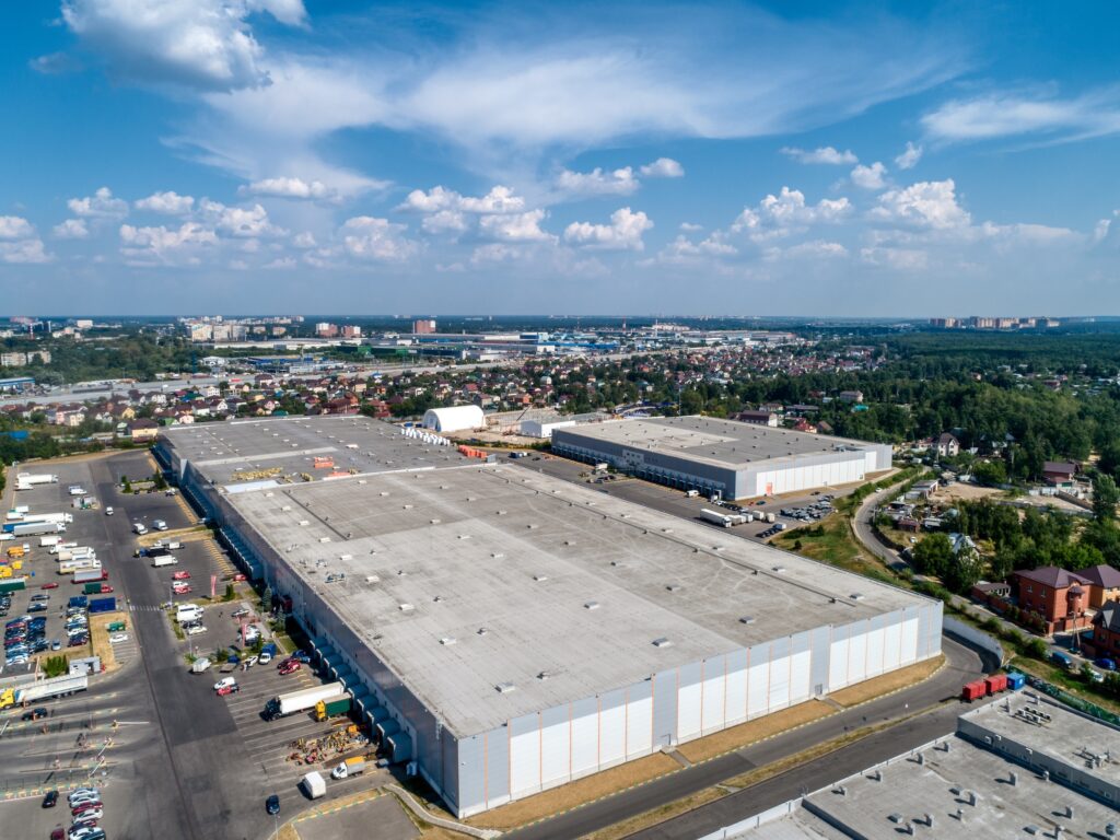
When an owner asks how many square feet of roof a portfolio actually carries, the honest first answer is usually "we are not sure." Drawings are decades old, additions went unrecorded, and field measuring forty buildings by hand is slow and expensive. Aerial and satellite roof measurement closes that gap by deriving roof geometry from overhead imagery and elevation data, producing area, slope, and perimeter figures without anyone climbing a ladder. Used well, it is a fast, defensible way to baseline a portfolio. Used carelessly, it quietly injects error into budgets and bid documents. Below we explain how the technology works, what it reliably delivers, where it fails, and how we put it to work for the owners we advise.
How Remote Measurement Actually Works
Aerial measurement relies on imagery captured from aircraft or drones, often paired with stereo photography or LiDAR that records elevation. Software, sometimes assisted by a human technician, traces roof edges, identifies facets and ridges, and calculates area, pitch, and linear footage of penetrations and parapets. Satellite measurement uses the same logic but pulls from orbital imagery, which is more widely available and cheaper but lower in resolution and refresh frequency.
The critical distinction is between a true measured surface and a flat outline. A low-slope commercial roof is close to planar, so a top-down footprint approximates the membrane area reasonably well. The moment you add tapered insulation crickets, mezzanine roofs at different heights, or steep architectural elements, two-dimensional outlines understate the real surface. Better providers incorporate elevation data so the geometry reflects the building, not just its shadow on the ground.
Where The Data Is Genuinely Reliable
For most flat and low-slope commercial buildings, overhead measurement of gross roof area is dependable and repeatable. It excels at portfolio-scale work where the goal is a consistent, comparable baseline rather than a fabrication-grade cut list. It also shines for properties an owner cannot easily access, such as occupied tenant spaces, secured industrial sites, or assets under a purchase agreement that has not yet closed.
- Gross roof area for budgeting, reserve studies, and reroof scope sizing
- Perimeter and parapet linear footage for edge-metal and coping estimates
- Building footprint comparisons across a portfolio for normalized cost-per-square-foot analysis
- Identifying large rooftop equipment, skylights, and obvious additions for due-diligence flags
- Pre-bid reference areas that keep multiple contractors quoting against the same number
The Limitations Owners Should Respect
No overhead method sees what it cannot photograph. Tree canopy, deep parapets that hide the field of the roof, recently constructed additions, and stale imagery all degrade accuracy. Satellite sources can be several years old, so a roof replaced last spring may still show its previous configuration. Resolution sets a floor on detail: small curbs, individual drains, and narrow saddles often fall below what the imagery can resolve.
Slope and tapered insulation are the most common sources of error. A system reporting a flat footprint will undercount membrane on any roof with meaningful taper or multiple levels, and that shortfall compounds into material and labor gaps. Overhead measurement also tells you nothing about what lies beneath the surface, the number of existing membrane layers, the condition of the deck, or saturated insulation, so it informs scope but never replaces a physical or moisture survey.
False Confidence And How To Catch It
The real risk is not random error but false precision. A report that prints an area to the square foot reads as authoritative even when the underlying imagery was ambiguous. Treat any single remote measurement as an estimate with a tolerance band, not a surveyed fact. The discipline that protects an owner is simple cross-checking.
- Confirm the imagery capture date and reject anything older than the most recent roof work
- Sanity-check reported area against tax records, original drawings, or a quick field tape on one representative roof
- Ask whether elevation data was used or whether the figure is a flat outline
- Add a contingency factor on measurements feeding firm bids, not just rough budgets
- Require a confidence note or accuracy statement from the provider rather than a bare number
Cost And Effort Versus Field Measurement
The economic case is strongest at scale. A single building rarely justifies the overhead of a remote-measurement subscription when a technician can tape it in an afternoon, but a portfolio of twenty or two hundred roofs is a different equation. Remote measurement turns weeks of travel, lift rentals, and roof-access coordination into a desk exercise completed in days, with consistent methodology across every asset. It also removes safety exposure, since no one is on a roof to gather a number.
The tradeoff is that remote data is a screening and budgeting tool, not a construction document. For final fabrication quantities, tapered insulation design, or warranty-grade submittals, a field verification on the specific roof still earns its keep. The smart pattern is to measure the whole portfolio remotely, then spend field hours only on the assets headed for capital work.
How We Advise Owners On Remote Measurement
We treat aerial and satellite measurement as the fast first pass that frames a portfolio, never as the last word. When we baseline an owner's holdings, we specify the imagery vintage we will accept, insist on elevation-aware geometry for any multi-level or tapered roof, and attach a confidence note to every figure that flows into a budget or bid. We reconcile the remote numbers against drawings and tax data, and we flag the handful of roofs where the geometry is ambiguous enough to warrant a field check.
Most importantly, we keep the method in its lane. Remote measurement tells an owner how much roof they have and roughly what edge and perimeter work it implies; it does not tell them how many membrane layers exist, whether the insulation is wet, or what the deck is doing. We pair the geometry with condition and moisture data before any capital decision, so the number that lands in a reserve study or a reroof bid is one the owner can defend.